It is not only the construction and maintenance of pavements that is evolving. Pavements are also evolving in terms of their role and their design. This is due to evolving vehicles and evolving practices in the operation of the road network.
ARRB’s Mobility Futures team has been looking into some of these aspects. Outlined below is a high-level overview of how road data, evolving vehicles and evolving road operations will impact pavement design and construction in the future.
1. Road Data
Road data can be provided through a smart pavement.
Intrusive Pavement Sensors
Pavements are already equipped with sensors that can inform road managers on how roads are being used, and to assist in the management and operations of the road network. They can also provide real-time data that can feed into the operation of traffic control systems. A pre-requisite for any intelligent traffic control system.
Monitoring and Evaluation
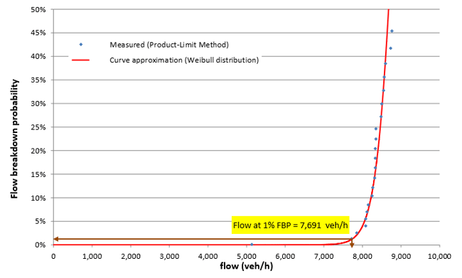
As road operations becomes a greater focus, relative to road construction and maintenance, there will be greater need to understand which road users (cars, freight, public transport, cyclists, pedestrians etc.) are using the pavements along with when and to what magnitude it is being used. Embedded pavement sensors (intrusive) play a role in addition to non-intrusive (above pavement) and probe data (connected communication technology). The adage of ‘if you cannot measure it, you cannot manage it’ certainly applies to road networks. This is particularly relevant to motorways and more broadly arterial roads. In 2020, ARRB completed the ‘Improved traffic management guidance: Freeway capacity analysis’ report for Austroads (AP-R644-20). This report highlighted the methodologies used to monitor freeway capacity, all of which rely on high-quality local freeway data, sourced through various data sources, including intrusive pavement sensors.
To aid in the planning and operation of the road network, including the implementation of movement and place strategies (as outlined in the Austroads Guide to Traffic Management Part 4: Network Management Strategies – AGTM04-20, authored by ARRB), data is required. A smart pavement embedded with sensors to detect how the road network is being used is critical.
Data Fusion
Bringing together and synthesising the data from smart pavements and other sources is the role of the Advanced Technologies Lab (atlab) within ARRB. ARRB’s Atlab co-ordinates data used and collected across the organisation including road condition, strength, roughness, lane widths, vehicle speed/counts/headway, probe data, weigh-in-motion (WIM), and crash statistics. The benefits of big data can be improved by applying ARRB’s knowledge and expertise through centralising datasets and implementing algorithms, analytics, and visualisations. When these layers of data are infused together, it generates multi-dimensional depth to the rich datasets to forecast and model important analytics.
2. Evolving Vehicles
Evolving vehicles will impact on pavement design and constructions as discussed below.
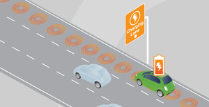
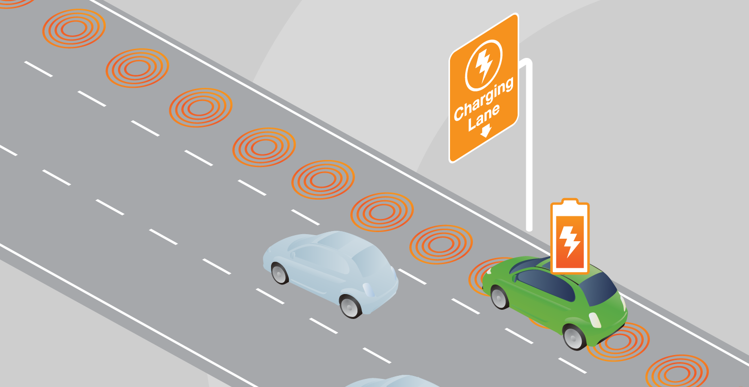
Electric Vehicle Inductive Charging
As electric vehicles evolve and become common, pavements may need to be equipped with inductive charging in order to charge electric vehicles (EVs) suitably equipped with the ability to be charged in that manner. In 2020, ARRB completed an ‘Assessment of key road operator actions to support electric vehicles’ for Austroads (AP-R641-20). This report highlights key actions road operators can take to support EVs. It includes monitoring the development of plug-less in-pavement charging systems.
Connected and Autonomous Vehicles
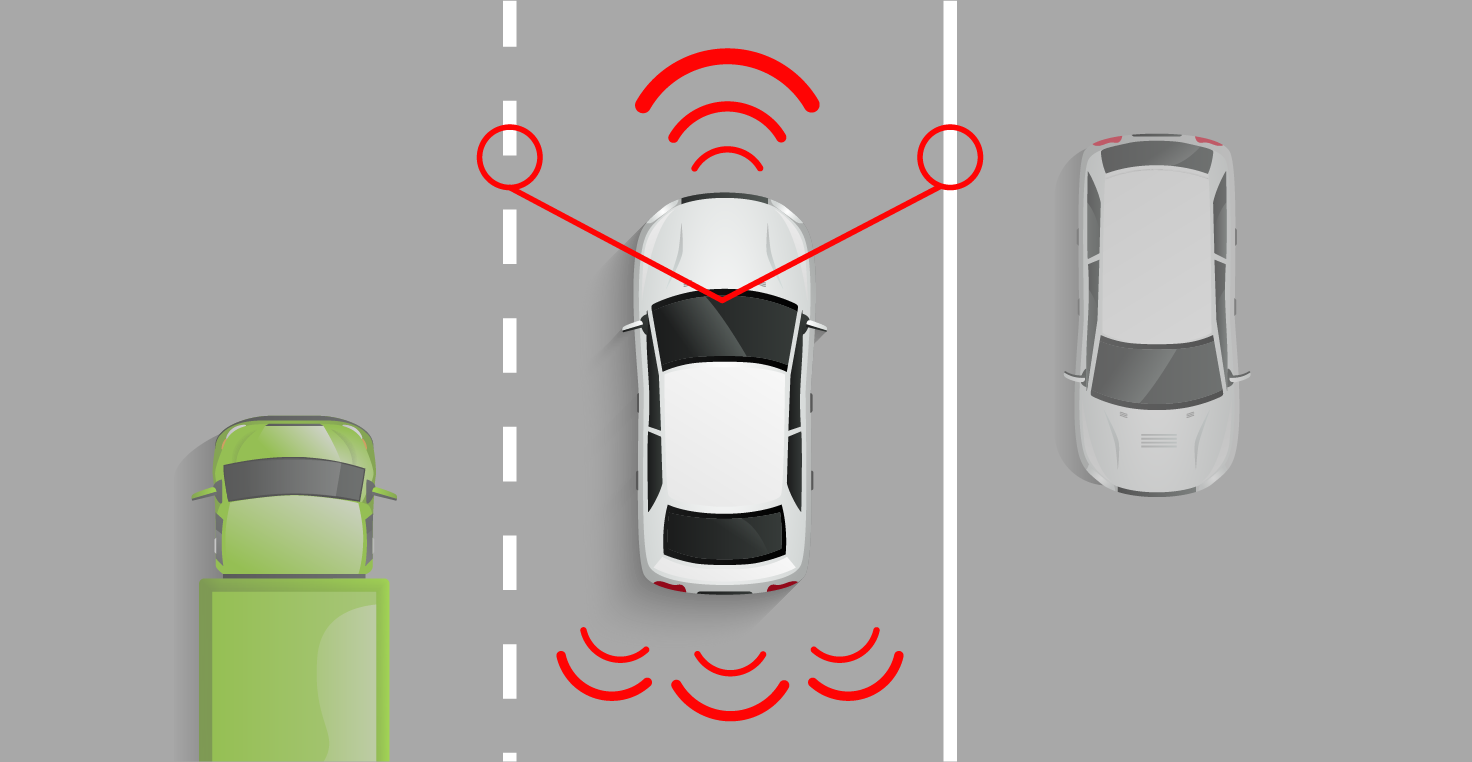
Connected and Autonomous Vehicles (CAV) are evolving, with that comes new abilities to be able to read the road and assist human drivers in driving the road. The ability for a CAV to read the road will influence how a road is designed, constructed, and maintained. Road managers need to understand this, so that that they can apply an appropriate level of investment now and into the future. This may impact on aspects associated with the pavement including line markings, lane widths, curvature, and shoulders etc.
Building on previous knowledge and experience, ARRB has just commenced (2021) a research project for Austroads titled ‘Minimum physical infrastructure standard for the operation of automated driving’ (Austroads project FPI6258). The purpose of this project is to provide advice to road agencies on the appropriate level of investment and infrastructure changes to support the operation of connected and automated vehicles.
Pavement Maintenance
Evolving vehicles may also be able to provide key data and information that can lead to enhanced maintenance of pavements. With a growing asset management task and competing needs and priorities, there is a need to know more about the state of the road network to help balance priorities. Evolving vehicles can play a role in this. As connected and automated vehicles evolve there is potential that data may be collected on pavement conditions, with this information communicated (via cooperative intelligent transport system (C-ITS)) back to road agencies and fed into their asset management systems and practices.
ARRB delivered various C-ITS research reports for Austroads which have investigated various aspects of C-ITS and have provided information to Austroads member on the framework to enable communications to occur between vehicles and between vehicles and infrastructure (roadside infrastructure and centres).
3. Evolving Road Operations
Road operations are evolving. This will require data and information obtained through sensors and will alter how roads are operated in the futures. Some of the key elements that will influence pavement design and construction into the future are highlighted below.
Dynamic Road Cross-section
The ARRB prepared Austroads report titled ‘Freeway design parameters for fully managed operations’ (AP-R341/09) managed motorways now and into the future will contain elements and features that enable the cross-section of the road to dynamically alter based on real-time measurement of the traffic conditions. This can include the ability to close lanes in response to an incident, allow shoulder lane use (in conjunction with other aspects such as speed management and the use of emergency refuge areas), and to apply reversible lane systems to better accommodate tidal flow.
With improvements in vehicle technology (e.g. driver assistance systems such as lane keep assist technology) and evolution of road operations (lane use management systems and variable speed limits) lane widths less than the standard 3.5 m width where appropriate may be considered.
While not widely used, dynamic lane marking utilising LED lighting elements installed within the road surface has the ability to give the appearance of a line. This is a technology that may emerge as a tool in the future.
Maintaining Parking Equity
Maintaining flow and parking equity is critical to road operations. Already starting to be used in time limited parking places are intrusive pavement sensors that can measure the time period that a vehicle has been stopped within a parking place. This can aid in the enforcement of parking places, aiding parking equity. Inductive EV charging may also be provided at car parking spaces in the future.
Ride Share
In places with high turn-over of people the use of ride sharing is causing issues to road operations as ride sharing vehicles may stop in through lanes while the service picks-up and/or drops-off passengers. There is a need to plan for and cater for this through the provision of pick-up and drop-off zones that will enable the activity to be undertaken clear of through lanes.
Improving Road Safety
Sensors can be used to detect a hazardous scenario (e.g. hazardous pavement condition such as black ice, or an approaching vehicle at a rural intersection). This information can be communicated and displayed on a variable message sign, communicated to an approaching equipped vehicle via wireless connection (C-ITS), and/or result in a change in the speed limit and displayed on a variable speed limit. All potentially resulting in a positive safety outcome.
4. Contact us
If you would like to know more about how the role of pavements may change into future, through road data, evolving vehicles and evolving road operation practices, the team at ARRB’s Mobility Futures team. Please contact us at info@arrb.com.au to discuss further.