The Australian Road Research Board (ARRB) is conducting a comprehensive road survey in the Northern Rivers region, which will inform the rebuilding effort and improve its ability to withstand future floods.
After the severe flooding in Northern New South Wales in 2022, ARRB has worked with the Department of Regional NSW (on behalf of the Northern Rivers Reconstruction Corporation), to support the efforts to build road infrastructure more resilient to future flooding events.
The Northern Rivers region is around seven hours north of Sydney and is home to close to 300,000 people. The region has been devastated by severe flooding, particularly in February and March of 2022, with more than 1,300 people displaced from their homes.
Flooding can also cause catastrophic damage to roads, either through potholing or washing roads away completely, disrupting travel and freight at critical junctures. ARRB’s work is intended to provide a snapshot of the conditions of the sealed roads across the region after the floods.
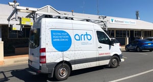
ARRB has sent out both the Intelligent Pavement Assessment Vehicle (iPAVE) and the Network Survey Vehicle (NSV) to assess more than 6,500kms of road in the region.
The iPAVE helps assess the condition of road pavement. It has lasers and cameras mounted on it that collect information about the road as it drives. The information gathered includes the strength of the pavement, roughness, cracks, and other important details. This information helps road managers determine which areas of the road might have problems in the future and helps local governments decide where to spend money on road maintenance.
The NSV provides similar information, using laser profiling and automatic crack detection to determine the condition of road networks.
Between them they are gathering digital imagery and measuring roughness, texture, and rutting of the roads, and identifying the weaknesses that can make roads prone to water damage.
The data collected by our survey vehicles will be used by local councils to inform and direct their maintenance efforts to where they’re needed most, to restore and remedy vital infrastructure.
The project is due for completion by the end of March this year.
The collaborative efforts of ARRB and NRRC in the Northern Rivers region will lay the foundation for the rebuilding and restoration of the local road network and restore some stability to those affected.
Executive Director (Roads) for the National Transport Research Organisation Jeff Doyle said ARRB is working quickly to provide the NRRC with the necessary data to make informed decisions about restoring and building resilience in their road network.
“The recent floods have highlighted the fact that roads are the infrastructure upon which almost all other infrastructure depends, they are the blood vessels of an economy. Our state-of-the-art data collection technology allows for better community, safety, economic and maintenance decision making,” he said.
You can find out more about our iPave here, or about the NSV here.
