
The Australian Road Research Board's (ARRB's) Future Transport Systems (FTS) team is helping road managers and other interested stakeholders deliver future mobility solutions.
A key part of future mobility solutions is ensuring safe mobility is achieved for all road users. This is undertaken through helping road managers deliver the four themes of a safe system network which consist of (Infrastructure and Transport Minister (2021)):
- Movement and place – Speed management (safe speeds)
- Safe roads
- Safe vehicles
- Safe road use (safe people)
ARRB’s Transport Safety team specialises in delivering road transport related safety projects. The FTS team work in collaboration with many other strategic working groups and contribute to safety related projects where specialist advice is sought.
The FTS team lead projects that focus on future mobility. These projects are delivered cognisant of the safe system themes. Outlined below is a high level overview of how the FTS team has achieved this.
1. Safe System Theme 1 – Movement and Place: Speed Management
Embedding Movement and Place into Austroads GTM
The FTS team has worked with Austroads to update the Austroads Guide to Traffic Management Part 4: Network Management Strategies (Austroads 2020). Part of this was to ensure that the Movement and Place framework, which has been developed by others and continues to evolve, ties into Network Management Strategies used by road agencies and is the key overarching framework for the development of network operation planning principles. A key part of helping road managers implement network operation planning is the level of service framework developed by the FTS team.
Level of Service (LOS) Framework
As part of two Austroads research reports (AP-R475-15 (Austroads 2015a) and AP-R499-15 (Austroads 2015b)) delivered by the FTS team, a LOS framework was developed and delivered. The LOS framework helps practitioners assess in a uniform and consistent manner, the LOS that treatments to the road link deliver for the various road users (private motorist, transit users, pedestrians, cyclists, and freight operators) and across their various needs (mobility, safety, access, information, and amenity).
The LOS framework can be applied to current treatments and proposed treatments. By applying the LOS framework, a practitioner can assess and understand the impact a change in the road link can have on either other road users and/or other needs. This can help in understanding the trade-offs of such treatments. For example, will a reallocation of road space to provide a bicycle lane to enhance the safety LOS for cyclists along a specific road link, impact on the mobility LOS of other road users, and by how much.
Combined with policy objectives of the link which can be based on the Movement and Place framework, practitioners can assess how well the link and/or proposed treatment on the link meets with the overall objective in terms of LOS for the various road users and needs. For many road links there is an obvious focus on both the safety and mobility needs. The goal LOS rating for the various road users and needs will be dependent on the objective of the road. For example, it would be acceptable to have a low mobility LOS for freight operators in a local residential street, as the objective would be to provide safe access for private motorists, pedestrians and cyclists and not freight mobility.
Input to Local Government Bicycle Strategies
The FTS team has used the knowledge from Movement and Place and the Level of Service Framework development to provide advice on Local Government’s Bicycle Strategies. This is to help the road managers provide a safe and efficient bicycle network, and better cater for existing cyclists while also encouraging new ones to shift over to this form of transport for either recreation, local transport, commute, fitness and/or other means as deemed appropriate.
In doing so, the FTS team has provided advice on how to strengthen bicycle strategies by referencing Austroads frameworks such as Movement and Place, Network Operation Planning and Level of Service frameworks. Advice was also given to highlighting how the bicycle strategy could:
- Refer to other emerging vulnerable transport modes that may utilise the bicycle facilities such as electric bicycles and scooters.
- Utilise crash data for bicycles to review how the Maribyrnong jurisdiction is performing with respect to bicycle crashes.
2. Safe System Theme 2 – Safe Roads
Traffic on Rural Roads (TRARR)
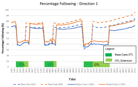
TRARR, which derives its name from ‘traffic on rural roads’, simulates the flow of traffic along a two-way, two-lane road and allows the assessment of whether overtaking lanes may be required. TRARR models the road’s specific geometric profile, which consists of the horizontal curvature, gradient and crossfall, as collected by ARRB’s survey vehicles.
It generates spot average speeds and the percentage of vehicles that are in following mode according to selected vehicle groups. Examination of these profiles will enable identification of potential suitable locations of overtaking lanes, with the number of overtaking lanes suggested based on the level of service desired. The safety benefit of improving the level of service on the road is that there will be less vehicles in following mode. This will help to minimise the chance that drivers will undertake risky manoeuvres to overtake.
The FTS team has undertaken TRARR assessments for various key rural freight routes across various Australian road agencies. Figure 1 shows an example of the output of the TRARR modelling and the impact that overtaking lanes (OTL) has on the percentage of vehicles following.
Currently the FTS team are developing a new simulation tool to replace TRARR which will be called ROAM (Rural Overtaking Assessment Model). ROAM will be an online tool with an integrated user interface that will improve on the functionality of TRARR.
Figure 1: TRARR modelling
Semi-Automated Vehicles and Cooperative Intelligent Transport System Technology in Vehicles
Semi-automated vehicles (AV) and cooperative intelligent transport system (C-ITS) technology in vehicles has the potential to deliver road safety benefits. How the vehicles interface with existing roads needs to be understood through operational deployment of equipped vehicles on existing roads. This is what the FTS team did with an operational deployment of equipped vehicles on Eastlink (which is a major toll road motorway located in the south east of metropolitan Melbourne).
Under the Smarter Journeys program, managed by the Victorian Department of Transport, the FTS team, in partnership with Connect East and La Trobe University, undertook a study of the operational deployment of semi-AVs and C-ITS on Eastlink across three phases as follows:
- Phase 1
Investigate Level 2 partially automated vehicles along a section of Eastlink, between Springvale Rd and the Monash Freeway, including the Mullum-Mullum tunnel.
- Phase 2
Investigate the connectivity using dedicated short range communications (DSRC) and develop a C-ITS testing methodology to test any interference with the DSRC electronic toll collection (ETC) infrastructure.
- Phase 3
Investigate the communication of road work warning (RWW) messages to the in-vehicle human machine interface (HMI) advising the vehicles and passengers in it of the upcoming road works area and other messages. The message format used was the standardised Decentralized Environmental Notification Message (DENM) sent over the 5.9 GHz DSRC frequency (ITS G5) from the roadside unit (RSU).
Connected and Automated Vehicles (CAV) Readiness Survey
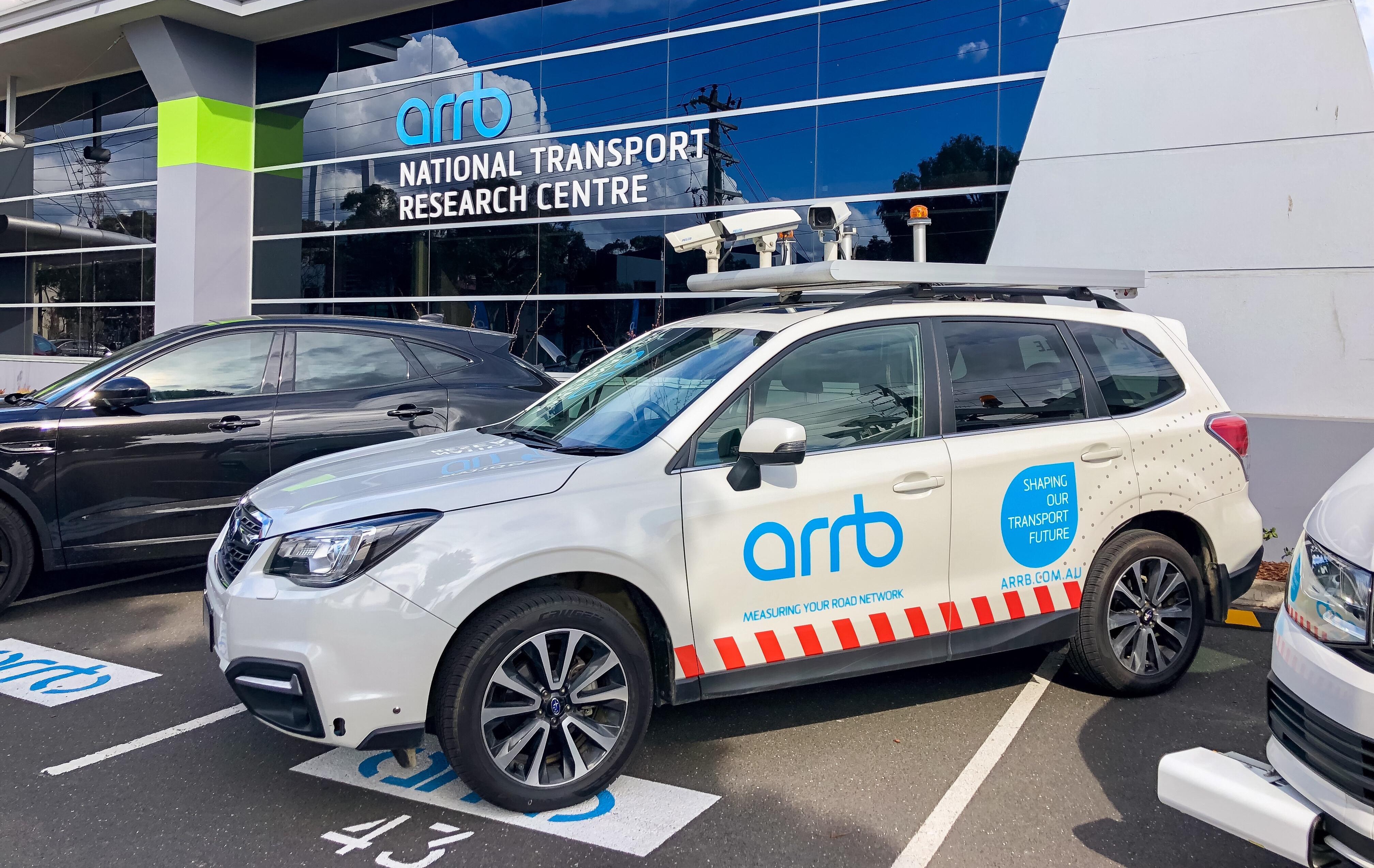
Connected and Automated Vehicles (CAV) will play a key role in the future of transport in Australia. Appropriate road surfaces, signage and line markings play an essential role in their operation. The Advanced Technology Lab of the FTS team can work with road managers to survey and audit the road infrastructure to assess the CAV readiness of the road network.
Using the latest artificial intelligence (AI) cameras developed by Mobileye and equipped to survey vehicles (refer to Figure 2), ARRB is able to undertake an audit in real time, reading and cataloguing the road while the vehicle is driving alongside it. Embedding AI and streamlining the process as ARRB has done, allows for faster results, more efficient data collection and lends itself to cloud storage and retrieval. It also enables the audit to be undertaken from a machine vision system perspective.
Figure 2: ARRB’s Mobileye equipped survey vehicle
The CAV readiness audit assesses aspects such as:
- Speed signs: Signs are identified, classified, and processed in real-time to generate an inventory of information including spatial location.
- Lane width: Lane widths are measured with precision and stored in a database for further analysis.
- Line quality: Line markings are assessed for suitability to be read by vision systems used by connected and automated vehicles.
- Line width: Line widths are analysed and assessed in real time by vision systems used in autonomous vehicles.
Road Safety Dashboard
The FTS team has developed a Local Government Road Safety Dashboard which allow road managers to select a local government area and display their crash history and crash risk profile. The dashboard includes an interactive web map and road safety metrics which are displayed as charts and tables. The dashboard has been used during a workshop with the federal transport minister and local government representatives. This allowed participants to quickly access and compare the crash history of local government areas.
3. Safe System Theme 3 – Safe vehicles
Dynamic Performance of Heavy Vehicles
The FTS team has a long history of assessing the dynamic performance and impacts of a range of freight vehicles carrying over-mass containers. Past projects have assisted road managers understand the impacts of these heavy vehicles, with the aim being to improve productivity and safety and maximise the benefits to the road freight industry and the wider community.
Advanced Safety in Vehicles
The FTS team has undertaken a review to identify existing and emerging vehicle safety features that could potentially be introduced into Australian regulation for passenger vehicles and trucks, based on the technology being mandated in Europe. This included assessing the timeline to implement regulations and potential safety impact of the technologies.
4. Safe System Theme 4 – Safe Road Use
Pedestrian Survey
ARRB's FTS team also explores the safe use of the road. In 2018, the FTS team undertook two projects to understand pedestrian behaviour when crossing the road and investigate methods to improve safety of pedestrians when undertaking this movement.
The first project involved a survey of pedestrian speeds related to walk time (green pedestrian signal) and clearance time (flashing red pedestrian signal). This was undertaken using video data and motion video analysis software as shown in Figure 3. The main objective was to investigate pedestrian speeds for designing green and flashing red pedestrian signal time.
The second project involved undertaking a risk assessment of a proposal to automatically introduce the pedestrian walk phase at a signalised intersection. The pedestrian walk phase operates by automatically activating the pedestrian walk phase whether there is a pedestrian waiting to cross or not; hence, there is no need for a pedestrian push-button.
Figure 3: Pedestrian speed survey
.png?width=620&name=Figure3-Pedestrian%20speed%20survey%20(a).png) |
.png?width=617&name=Figure3-Pedestrian%20speed%20survey%20(b).png) |
Human behaviours
ARRB’s FTS team has behaviour experts experienced with investigating how humans interact with the road environment and future mobility systems. Findings from such investigations may shape factors influencing these interactions, including policy. Investigations include:
- Field operational test (FOT) of connected light vehicles to increase understanding of the public acceptance, issues surrounding deployment, safety benefits, and limitations of cooperative intelligent transport systems (C-ITS).
- A review and understanding of driver distraction. This included understanding the impact on driving performance and crash risk of drivers engaging in secondary tasks. It also included understanding the types of technologies and methods used to detect and measure physiological symptoms and presentations of driver distraction, along with a review of guidelines developed to reduce the negative impact on driver performance of human-machine interfaces (HMI) for in-vehicle technologies.
- An instrumented vehicle and eye tracking study to examine how drivers interact with roadwork zones. The study included understanding how drivers interact at roadworks sites as a result of countermeasures designed to improve safety in roadwork zones. The countermeasures comprised of variable speed limit signs and yellow line markings.
- Providing expert advice for the development and evaluation of a trial to understand how telematics could be used to improve young driver behaviour. The young drivers’ who participated in the study had their vehicles fitted with telematics and accelerometer technology which provided real-time and post-driver feedback on driving performance.
5. Contact Us
Future mobility will require integration of different services. Referred to as an integrated mobility service, services to be integrated include transport services, transport infrastructure services, authority regulations, planning and optimising services, security services, payment services, information services and ICT services. Each of the services will critically rely on cloud-connected data for their proper functioning and to achieve the outcome of an integrated mobility service for all road users. Such an appreciation by practitioners provides the context from which to address the options and guidance necessary to work with all services and industry to deliver safe and efficient journey outcomes for road users who are cloud-connected. ARRB’s FTS team can provide advice to stakeholders to achieve this.
If you would like to know more about how safe mobility can be delivered through Future Transport Systems, the team at ARRB will be more than happy to assist.
Please contact Dickson Leow at 0477 704 313 or at dickson.leow@arrb.com.au to discuss further.
6. References- Austroads 2015a, Level of service metric (for network operations planning), AP-R475-15, Austroads, Sydney, NSW.
- Austroads 2015b, Development of the accessibility-based network operations planning framework, AP-R499-15, Austroads, Sydney, NSW.
- Austroads 2020, Guide to Traffic Management Part 4: Network Management Strategies, Austroads, Sydney, NSW.
- Infrastructure and Transport Ministers 2021, National Road safety Strategy 2021-30, Department of Infrastructure, Transport, Regional Development and Communications, Canberra, ACT, viewed 22 March 2021, <https://www.officeofroadsafety.gov.au/sites/default/files/documents/draft-national-road-safety-strategy.pdf>.